Run a Survey - How to survey using the Open Sonar System
So, now you have a boat and you have a sonar system. What is next? How do we actually get this stuff to the water and collect some data? I am glad you asked! This section will walk you through all you need to know to go out and survey!
By the end of this tutorial you should know:
- What to pack for a day of surveying.
- How to transport the gear to the survey site.
- What sorts of site characteristics might be preffered or avoided.
- How to turn on the system and communicate with it from shore.
- How to configure the system for use.
- How the different modes of navigation can be used.
- How to launch the vessel
- How to collect data.
- How to retrieve data from the vessel.
- What to do at the end of the day to maintain the vessel.
- How to process and visualize the data.
Packing
Before heading out to the survey site we need to make sure all the necessary supplies are packed. This will prevent the headache of trying to make do without, or heading all the way back home without doing a survey. We reccomend making a checklist that can be used by anyone heading out to survey to ensure they have everything they need.What to pack:
- The Open Sonar Vessel
- The Open Sonar System
- Shore computer
- Shore telemetry radio
- Shore wifi antenna
- Spare batteries
- A rope
- A flathead screwdriver
- A sense of adventure :)
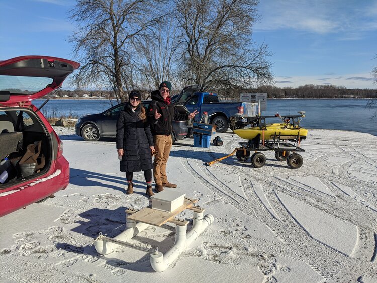
Transporting the Open Sonar Vessel
The vessel you have built is pretty sturdy, but you want to keep it safe while you transport it. Place it flat inside the vehicle. Make sure it is not resting on the motors, and that it cannot slide around on corners or when braking. Be sure to disconnect the sonar and GNSS pole and tuck it away into its transport position on the side of the main platform.Site Selection
While it would be great if we could go survey anywhere, this is sadly not the case... There are certain characteristics about a site which might make it more difficult or dangerous to survey at. Sites with these characteristics should be avoided if possible. Conversely, there are some site characteristics that make things easier for us, so lets talk about them first.Things to look for in a site:
- Easy access to the water
- No obstructions in the survey area
- Open sky view in the survey area
- Low amounts of boat traffic in the area
- Calm water with little current or waves
Things to avoid if possible:
- No access to the shore
- Obstructions in the water
- Obstructions in the sky view
- Boat traffic
- Currents, waves, wind
Turning on the System
This is the process for turning on the systemConfiguration of the System
Once the system is turned on, we need to create a configuration file for the survey. This can be accomplished in two ways: firstly by using the Open Sonar Configurator program to set up all appropriate configuration metadata; or secondly by using an already existing configuration file. The configuration files are just .csv files, so they can be edited easily if so desired.The information contained within the configuration file is primarily metadata related to the survey and to the vessel, as well as the communications pathways to be used by the vessel to talk to the sensors attached to it. The following list details all the information contained in the configuration file, an example of which is seen here.
Navigation Modes
The vessel can be navigated using several different methods to allow either manual control, or autopilot control where the vessel will follow pre-determined paths. Typically, manual mode will be used to drive the vessel away from the shore and to the survey area, while automatic mode will allow the vessel to follow pre-set routes to conduct the actual survey. The methods for using each of the modes is listed below.Launching the Vessel
Launching the vessel is a simple process, though along with retreiveing the vessel is one of the most common times for damage to be caused to the vessel. The steps below outline the process of launching the vessel, and the reverse can be followed to retreive the vessel.- Ensure that the thrusters are in their down position. You may need to unscrew the hose clamps and rotate the thrusters out of their transport location.
- Ensure the vessel is on.
- Arm the thrusters.
- Test the thrusters in manual mode briefly. Do not run them for a long time or at full power as they may be damaged by doing so out of the water.
- Disarm the thrusters.
- Fasten the rope to a bow cleat on the vessel.
- With two people, carry the vessel to the water and set it down with the bow facing into the shore. This is done so that the thrusters are in the deeper water.
- Ensure that the vessel is floating and has sufficient clearance below the thrusters.
- Lower the sonar pole into the position specified in the configuration file.
- Arm the motors and slowly back the vessel away from shore to a safe distance.